The Canoe Is the People
Indigenous Navigation in the Pacific


Dead Reckoning
This way of tracking a boat’s position is quite different from the etak system that Carolinian navigators use.
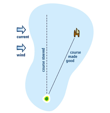
1. In the past, western navigators used to keep track of their heading GLOSSARY heading - the course or direction in which a boat is steered (different from its course made good) with a magnetic compass. They worked out the distance they had sailed by throwing an object overboard and measuring how far and how fast it was left behind.
2. They estimated GLOSSARY estimated - worked out, calculated how the leeway GLOSSARY leeway - the sideways movement of a boat, caused by the wind and currents GLOSSARY currents - the directional flow of the sea were affecting their heading and speed.
3. With this information, they reckoned GLOSSARY reckoned - estimated, calculated how far and in what direction their boat had sailed over a certain time period – for example, 200 km at 90 degrees (straight east) over the last 24 hours.
4. They then marked the boat’s position on a navigation chart and made any necessary course changes.
Today, the Global Positioning System (GPS) get that information instantly, making life even easier! A GPS is a hand-held computer that automatically tells sailors their position by communicating with satellites GLOSSARY satellites - electronic machines that orbit Earth . But if the batteries run low, or the satellites fail, modern navigators are usually without training or experience in other methods.