The Canoe Is the People
Indigenous Navigation in the Pacific


Interrupted Swells
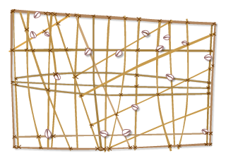
As well as using swells GLOSSARY swells - rolling waves caused by trade winds and storms to set his course, a wayfinder uses interrupted GLOSSARY interrupted - broken swells to find land. He knows that they mean land within 50 km. Marshallese wayfinders have very sophisticated GLOSSARY sophisticated - highly developed knowledge about the behaviour of swells and currents GLOSSARY currents - the directional flow of the sea , which can be their main guide. They use stick charts to represent and memorize the interrupted swells and currents for many important islands. Here are two examples of the knowledge that a stick chart might show.
1. One swell meeting an island
When a swell meets an island, some swell reflects GLOSSARY reflects - bounces off it, and the rest diffracts GLOSSARY diffracts - the bending of waves around obstacles in their path around it and joins on the other side. Where the two parts join, the sea is limaajnono (choppy, broken up, rough). Closer to the island, there is a calm area where the swell doesn’t reach.
• If wayfinders are sailing against the swell, they feel the pattern change when meeting the choppy water. When, again reaching calm water, wayfinders will stay in it to find land.
• If wayfinders are sailing with the swell, they can feel his canoe pause slightly when it meets the reflected swell. The reflected swell is shorter than the main swell and at a different angle. The navigator can steer directly into it to find land.
2. Opposite swells meeting an island
Two swells coming from east and west (that is, from opposite directions) will curve around an island and meet north and south of it. The meeting swells create an okar (line of swell peaks) that points to the island. When a wayfinder meets an okar, he knows that he is to one side of an island, even when he can’t see it. He can then sail down the okar to find land.
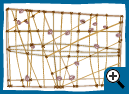
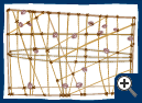
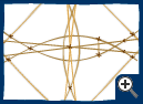
Mattang stick chart
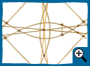
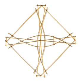
Rebbellith stick chart