The Canoe Is the People
Indigenous Navigation in the Pacific


Marshall Islands Ways
Stick Charts
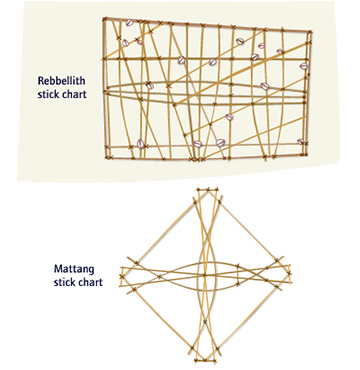
The Marshall Islands chain stretches along the face of the predominant swells GLOSSARY swells - rolling waves caused by trade winds and storms . This makes the swell very useful for navigation. Teachers make young navigators lie on their backs in the ocean to learn how to feel the swells. For teaching the main patterns, the Marshall Islanders tie sticks together. They attach shells to indicate islands.
• The mattang is a sophisticated GLOSSARY sophisticated - highly developed model used to teach students how swells bounce off islands and affect one another.
• The rebbellith and meddo are navigational charts that show how to get from one island to another by following the best pathway among the swell patterns. A return voyage has a different chart. The rebbellith covers the Radak or Ralik island chains or both. The meddo focuses on a smaller group of islands.
Click here for more information about interrupted swells.
It would be embarrassing for a wayfinder to carry a chart with him on a voyage because he should already know what it shows and be able to sense the patterns that are present in the ocean. The patterns vary somewhat seasonally, and with wind and weather conditions, so wayfinders must know the man patterns and be able to adjust to actual conditions. In the past, only a few people were qualified to make the stick charts. .
Note: The above information is from research done over a hundred years ago by Captain Winkler of the German navy. It has yet to be confirmed by the few remaining people who know about stick charts. Other researchers talk of a wabebe chart (instead of a mattang), which they say shows the swells around a single island.